
Scale Your Surveys Safely with Drone Based 3D Solar Modeling Software
Eradicate costly measurement errors and rough plans that ruin your installation day. Without needing extra software or dangerous roof climbs, turn drone imagery into a precise 1:1 solar digital twin. Instantly generate accurate layouts and carbon emission reports to win more contracts confidently.
Das Team ist sehr freundlich. Bei Problemen wird 24/7 immer geholfen. Das Programm funktioniert gut.

At Lion Solar Solutions, accuracy and speed are critical to our projects. Render-A exceeded our expectations with both their easy accessibility and technical expertise. The 1:1 measurement precision of their 3D models and the detailed analysis reports provided significantly accelerated our PVSOL project phases and reduced our workload. We thank them for their professional partnership.
The Hidden Costs of Manual Solar Site Surveys
Unreliable Data Baselines & Physical Limits
Relying on outdated Google Maps imagery or manual field visits severely limits your project accuracy and daily capacity. This approach misses critical real-world details, forcing you to base your entire scaffolding or survey plan on low-resolution guesswork.
Overcomplicated CAD Workflows
Forcing your engineers to waste hours in heavy CAD software just to reconstruct a base 3D site model from raw field data creates massive operational bottlenecks.
The Domino Effect of Non-Precise Planning
Lack of engineering-grade precision leads to costly mid-project surprises, such as mismatched scaffolding components or flawed terrain models. These on-site discrepancies force expensive emergency redesigns that instantly destroy your profit margins.
Scale Your Operations with the Ultimate Drone-Based Building and Site Measurement Software
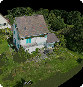
Transform Roof Surveys: Safe, Fast, and DIN-Certified
Keep your crew safely on the ground and eliminate costly return trips. Render-a turns dangerous manual roof climbs into a quick drone flight:
-90% faster measurements with complete 3D model delivery in 2 hours.
-9x more accurate than satellite imagery.
-99.9% accuracy backed by DIN-standard measurements.
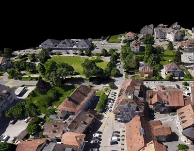
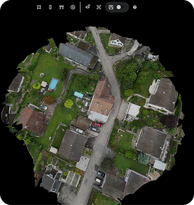
Conquer Hard-to-Reach Terrains
Just fly your drone over inaccessible land, and let Render-a build the 3D model:
-Effortless Mapping: Advanced drone photogrammetry with a very fast turnaround.
-Flawless Execution: Guarantee install-day fitment accuracy on complex topographies.
-Approval-Ready: Precise terrain data for rapid design validation and regulator approval.
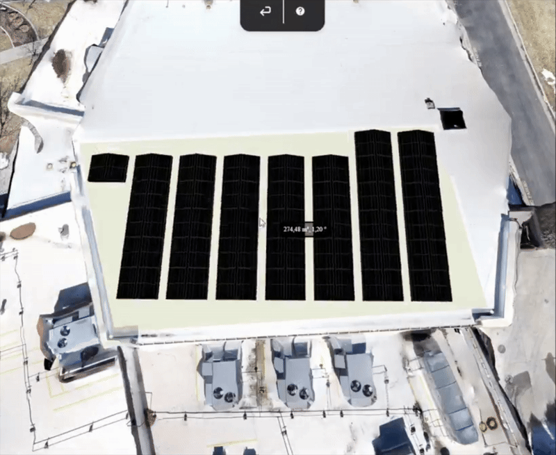
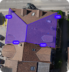
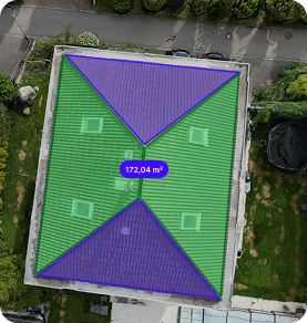
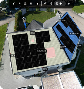
Go Beyond Measurement: Design & Pitch in One Workspace
Don’t just measure the site; act on it. While other platforms force you to export data to heavy CAD or design software, Render-a offers an all-in-one workflow. For solar and roofing professionals, you can transition instantly from a 3D digital twin to precise panel layouts. Perform real-time shade analysis, execute design validation, and generate winning proposals without ever leaving the platform.
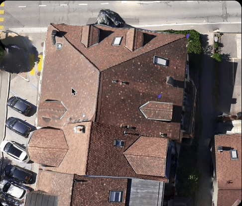
3D Facade & Scaffolding Measurement
Replace dangerous manual measurements with a quick drone flight. Get your complete 3D model in just 2 hours not the next day:
-Capture in Minutes: Centimeter-precise facade and ground details safely from the ground.
-2 Hour Delivery: Skip heavy CAD training; start planning your scaffolding immediately.
-Flawless Execution: DIN-certified data ensures exact material orders and zero waste.
Engineering-Grade Technical Reporting
Millimeter-Accurate Digital Twins
Stop waiting days for a base model. Generate 1:1 scale digital twins in just 15 minutes to 3 hours. Achieve 99.9% accuracy with DIN-standard precision to eliminate manual drafting and ensure a perfect fit, every time.
Actionable Performance Reports
Don’t settle for simple visual models. Render-a provides the data-driven authority you need with precise energy yield estimates and carbon footprint reports technical documentation designed for quick bank approvals and professional handovers.
Seamless Cloud & Video Workflow
Experience total flexibility. Start your render directly from Google Drive, Dropbox, or OneDrive. Our advanced engine even transforms Hyperlapse videos into high-quality 3D models, removing the friction of traditional, static photo-only tools.

How does Render-a work?
This is just a preview there’s so much more to discover in Render-a’s 3D world!
The New Standard for High-Speed, True-to-Scale Site Modeling
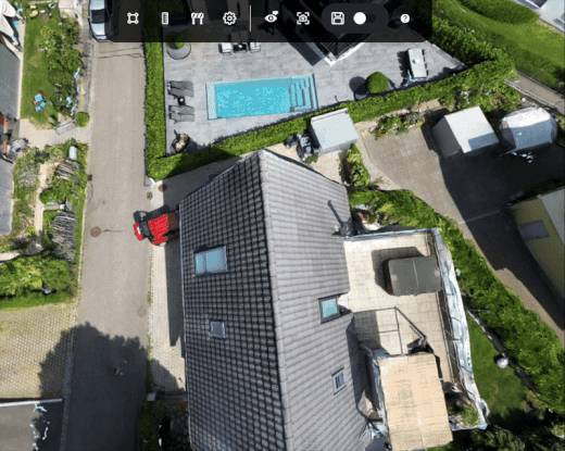
Survey-Grade 1:1 Digital Twins
Go beyond simple visuals. Our advanced photogrammetry pipeline converts drone data including Hyperlapse videos into georeferenced, 1:1 digital twins. Achieve 99.9% accuracy with DIN-standard precision, delivering measurable engineering data (Orthophotos, Mesh, Point Clouds) that reflects real-world coordinates.
Industry-Leading 2-Hour Delivery
Stop waiting days for a base model. Render-a offers a 95% faster measurement workflow, delivering high-fidelity models in 15 minutes to 3 hours. Start your renders directly from Google Drive or Dropbox and scale your daily survey capacity without the traditional “next-day” bottlenecks.
Data-Driven Performance Reporting
While others offer only visual models, Render-a provides actionable technical insights. Automatically generate precise energy yield forecasts, carbon footprint reports, and automated BOMs. Deliver the data-driven authority required for quick bank approvals and professional handovers.
Seamless Ecosystem Integrations
Eliminate manual data entry and rework. Render-a fits perfectly into your existing tech stack with seamless exports to PVSOL, PVsyst, AutoCAD, and Eturnity.We bridge the gap between field data and your favorite engineering software.
Precision Terrain & Facade Planning
Eliminate “it doesn’t fit” surprises on site. Utilize high-density Point Clouds and Elevation Maps (DEM/DSM) to plan complex scaffolding, terrain projects, or large-scale solar installations. Guarantee install-day fitment accuracy by identifying every architectural detail and topographical variation before you build.
Demo
- Includes pre-rendered 3D models and ready-to-use files
- No credits included
- No additional users allowed
- Online support available
- Self-measurement available on demo project
- No discount on extra credit purchases
Basic
- 20 3D renders or 20 file requests
- 200 credits/month (1 €/credit)
- Add up to 2 additional users
- Online support within 7 business days
- Interactive 3D model for self-measurement
- No discount on extra credit purchases
- Generate production reports by consuming credits
F.A.Q
Render-a is a platform that generates automatic 3D models and solar project-specific analyses from drone images. It enables all stakeholders, from sales teams to engineering departments, to work from a single source.
Render-a is optimized for solar energy, but its 3D modeling, measurement, and site analysis capabilities can also be applied in agriculture, construction, roof inspection, and real estate.
GPS and LiDAR supported drones provide the most accurate results because they allow 1:1 measurements. However, you can also generate models using photos taken with a phone with the loss of scaling.
Yes. You can use any drone you prefer. We also provide a recommended flight protocol document.
Absolutely. All data is encrypted and stored securely, accessible only from your account. For more information, please review our Privacy Policy page.
It depends on the project size and number of photos. An average rooftop project takes about 30 minutes, while a large ground-mounted project may take a few hours.
There is no strict technical limit. For very large files, we recommend uploading in parts.
Your account is credited based on the package you choose. One render costs 10 credits. If you download the 3D model to use in another platform, an additional 10 credits are deducted. You can purchase extra credits anytime through the app.
Yes. Reports are generated in PDF format, customized with your company details, and ready to share directly with your customers.
Yes. The monthly solar production forecast data is optimized for Excel integrations. Other export formats are also available for more detailed feasibility studies.
• 3D models compatible with PVSol, PVSyst, CAD and SketchUp
• Panel layout, energy yield forecast, and carbon emission saving report
• Proposal documents
Yes. Report are created to match your corporate identity.
Yes. Downloads are available in formats compatible with SketchUp, AutoCAD, PVsyst, and PVSol.
Yes. The free package includes a demo project and gives you access to all Premium features.
Of course. We provide documentation, sample projects, and email support. You can always reach us at support@render-a.com.