
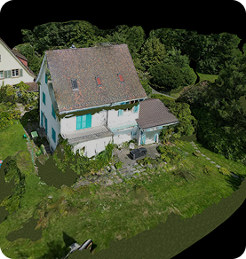
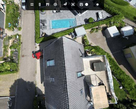
Drone data. 3D model. Precision planing.
Digitize your workflow with 3D modeling.
Leave manual measurement errors, late deliverables, and rough plans behind.
No tape measures, satellite imagery, or software required. Create a 3D model from drone imagery, plan panel layouts, and receive energy yield and carbon emissions reports.

Das Team ist sehr freundlich. Bei Problemen wird 24/7 immer geholfen. Das Programm funktioniert gut.

At Lion Solar Solutions, accuracy and speed are critical to our projects. Render-A exceeded our expectations with both their easy accessibility and technical expertise. The 1:1 measurement precision of their 3D models and the detailed analysis reports provided significantly accelerated our PVSOL project phases and reduced our workload. We thank them for their professional partnership.
Traditional methods lead to time and cost inefficiencies.
Measurement and data issues
Measurements can be inaccurate or inconsistent. Field changes don’t make it into the model, and working with outdated photos leads to contradictions.
Time and repeat visits
Site surveys, preliminary design, and proposal phases take too long. Repeated site visits delay projects and waste time.
Cost and safety risks
Incorrect measurements, unnecessary labor, and errors drive up costs. Sending people to hazardous areas increases safety risks.
Data management and communication gaps
Dimensions, notes, and reports are scattered across different places and formats. Misunderstandings and revision churn grow between sales, design, and installation teams.
Scalability and uncertainty
Traditional site surveys are hard to scale across large areas or multiple locations. Without accurate data and visualization, decisions rely on guesswork and risk remains high.
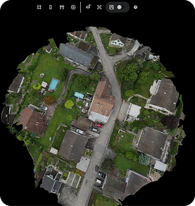
Use Render-a to convert drone data into a true to scale 3D model
Time and repeat visits
With Render-a, a single drone flight generates a detailed 3D model of the entire site, allowing teams to measure and plan remotely and shortening timelines.
Measurement and data issues
With Render-a, up to date drone captures enable millimeter-level measurements, and all models reflect field changes in real time.
Cost and risks
With Render-a, measurements are performed remotely, reducing costs and minimizing on-site safety risks.
Scalable Workflow with Centralized Data and a Shared 3D Model
With Render-a, teams work from a single 3D model, eliminating communication gaps and reducing revisions. Measure large areas in one pass, visualize multiple locations, and make data driven decisions that scale confidently.
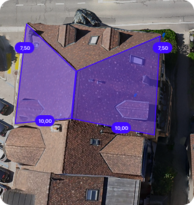
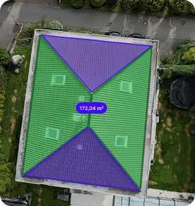
True to Scale Layout and Performance Report
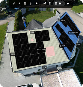
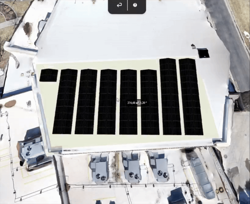
Roof Geometry & Layout
Installation-ready layout plans with millimeter-level measurements from a high-accuracy 3D model built from drone data.
System Options Comparison
Evaluate alternative configurations side by side in one report, with underlying assumptions visible, to select the optimal design.
Production Forecast
See energy yield projections alongside carbon footprint impact to make data-driven decisions.

How does Render-a work?
This is just a preview there’s so much more to discover in Render-a’s 3D world!
What we deliver?
Automated 3D Roof Model
Segments, arrays, panel count; key metrics like tilt, azimuth, and area.
3D Viewer
Zoom, measure, plan
Accurate Measurement
True-to-scale measurement from imagery, reducing manual errors.
Collaboration
Member management, permissions, and shareable links.
Integration Ready
Compatible with CAD workflows, PVsyst and PV SOL; supports OBJ, SKP, and TIFF
Demo
- Includes pre-rendered 3D models and ready-to-use files
- No credits included
- No additional users allowed
- Online support available
- Self-measurement available on demo project
- No discount on extra credit purchases
Basic
- 20 3D renders or 20 file requests
- 200 credits/month (1 €/credit)
- Add up to 2 additional users
- Online support within 7 business days
- Interactive 3D model for self-measurement
- No discount on extra credit purchases
- Generate production reports by consuming credits
F.A.Q
Render-a is a platform that generates automatic 3D models and solar project-specific analyses from drone images. It enables all stakeholders, from sales teams to engineering departments, to work from a single source.
Render-a is optimized for solar energy, but its 3D modeling, measurement, and site analysis capabilities can also be applied in agriculture, construction, roof inspection, and real estate.
GPS and LiDAR supported drones provide the most accurate results because they allow 1:1 measurements. However, you can also generate models using photos taken with a phone with the loss of scaling.
Yes. You can use any drone you prefer. We also provide a recommended flight protocol document.
Absolutely. All data is encrypted and stored securely, accessible only from your account. For more information, please review our Privacy Policy page.
It depends on the project size and number of photos. An average rooftop project takes about 30 minutes, while a large ground-mounted project may take a few hours.
There is no strict technical limit. For very large files, we recommend uploading in parts.
Your account is credited based on the package you choose. One render costs 10 credits. If you download the 3D model to use in another platform, an additional 10 credits are deducted. You can purchase extra credits anytime through the app.
Yes. Reports are generated in PDF format, customized with your company details, and ready to share directly with your customers.
Yes. The monthly solar production forecast data is optimized for Excel integrations. Other export formats are also available for more detailed feasibility studies.
• 3D models compatible with PVSol, PVSyst, CAD and SketchUp
• Panel layout, energy yield forecast, and carbon emission saving report
• Proposal documents
Yes. Report are created to match your corporate identity.
Yes. Downloads are available in formats compatible with SketchUp, AutoCAD, PVsyst, and PVSol.
Yes. The free package includes a demo project and gives you access to all Premium features.
Of course. We provide documentation, sample projects, and email support. You can always reach us at support@render-a.com.