
Scale Your Surveys Safely with Drone Based 3D Solar Modeling Software
Eradicate costly measurement errors and rough plans that ruin your installation day. Without needing extra software or dangerous roof climbs, turn drone imagery into a precise 1:1 solar digital twin. Instantly generate accurate layouts and carbon emission reports to win more contracts confidently.
Das Team ist sehr freundlich. Bei Problemen wird 24/7 immer geholfen. Das Programm funktioniert gut.

At Lion Solar Solutions, accuracy and speed are critical to our projects. Render-A exceeded our expectations with both their easy accessibility and technical expertise. The 1:1 measurement precision of their 3D models and the detailed analysis reports provided significantly accelerated our PVSOL project phases and reduced our workload. We thank them for their professional partnership.
The Hidden Costs of Manual Solar Site Surveys
Wasting Hours & Risking Lives
Sending crews up ladders for manual measurements limits you to 2-3 surveys a day. You are losing precious time, capping your business growth, and taking on massive liability risks.
Bleeding Margin on Return Trips
Relying on Google Earth guesswork (up to 90% error rates) or lost manual notes forces your team to revisit sites. Every return trip eats directly into your project’s profit margin.
Killing Your Sales Momentum
Telling a homeowner “we’ll get back to you with a design” gives them time to shop around. 2D paper plans fail to build an emotional connection, costing you hot leads.
Inaccurate Site Data & On-Site Revisions
When initial 2D paper plans fail to account for real-world roof vents or shading, your installation crews are forced to redesign on the fly. These unexpected discrepancies lead to wasted materials, extended labor hours, and compromised project margins.
Engineering Bottlenecks & Expensive Manual Drafting
Relying on highly paid engineers to draft simple preliminary proposals and manually calculate fire setbacks creates costly bottlenecks. Wasting hours on routine CAD drafting and permit plansets drastically slows down your sales cycle and drives up your pre-construction costs.
Scale Your Operations with the Ultimate Drone Based 3D Solar Modeling Software
Scale Your Survey Capacity by 5X-Safely
Keep your crew safely on the ground. With Render-a, you turn a dangerous 2-hour manual roof climb into a 5-minute autonomous drone flight. Empower your team to comfortably complete 15+ site surveys a day without adding extra headcount or increasing liability insurance.
Guarantee 100% Accuracy & Eliminate Return Trips
Stop relying on inaccurate Google Earth guesswork that leads to costly mistakes. Render-a’s advanced drone based 3D solar modeling software captures every vent, pitch, and tree shadow with centimeter precision. By generating a perfect 1:1 solar digital twin, you get all the exact data you need the first time. Zero return trips.
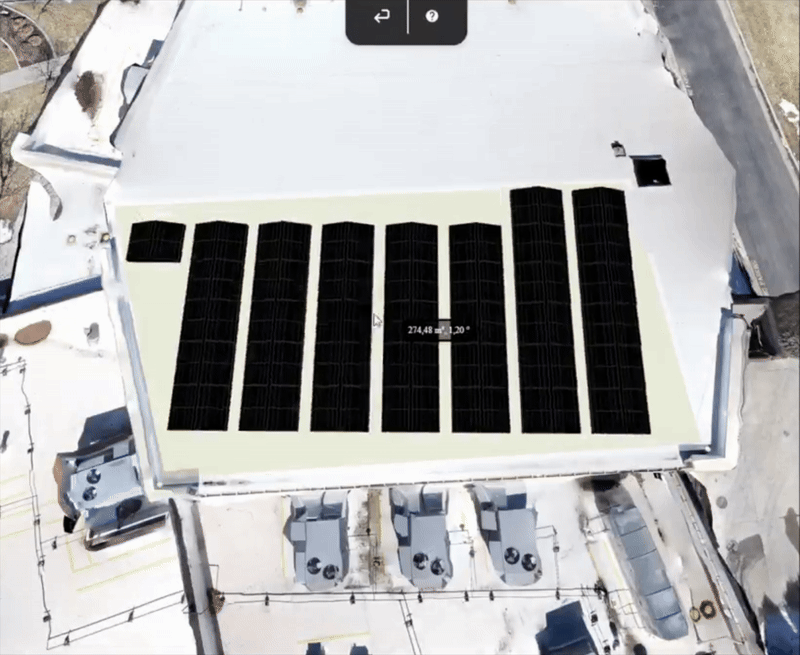
High-Precision Layouts & Reliable Material Planning
Eliminate on-site surprises and redesigns. By generating a centimeter-accurate 1:1 solar digital twin, you ensure your office designs align perfectly with the actual roof’s geometry. Instantly produce a complete Bill of Materials (BOM) to ensure your crews arrive with the exact inventory needed minimizing wasted labor and protecting your project’s net profitability.
Win the Contract on the Spot with Interactive 3D Proposals
Stop losing momentum with “we’ll get back to you.” Open Render-a’s interactive 3D model on your tablet and design the system directly with the homeowner in their living room. By allowing clients to participate in the layout process and choose their preferred components, you build instant trust and ownership. Close the deal before you leave by presenting real-time carbon footprint savings and professional environmental impact reports.
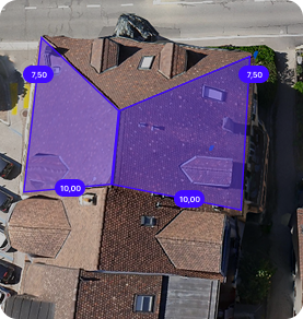
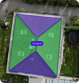
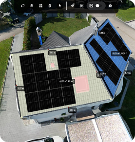
True to Scale Layout and Performance Report
Roof Geometry & Layout
Get millimeter-accurate layout plans from your 1:1 solar digital twin. You save hours on manual drafting and ensure a perfect fit the first time, every time.
System Options Comparison
Compare multiple configurations side-by-side. You gain the power to select the most efficient design, proving your expertise and maximizing your client’s ROI.
Production Forecast
Present precise energy yield and carbon footprint reports. You gain the data-driven authority needed for quick bank approvals and a faster closing process.

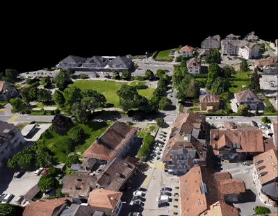
How does Render-a work?
This is just a preview there’s so much more to discover in Render-a’s 3D world!
Accelerate Your Business Growth with the Power of Render-a
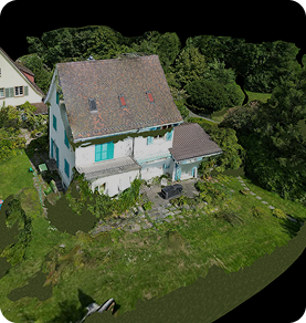
1:1 Digital Twin
Stop manual sketching and technical bottlenecks. Render-a converts drone data into a precise 1:1 solar digital twin automatically. You deliver error-free segments, tilt, and azimuth metrics in minutes, allowing your team to handle 5x more projects.
Close Deals on the Spot
Turn your proposals into an experience. Our interactive viewer lets you present designs directly to clients on a tablet. You gain a high-impact sales tool that builds immediate ownership, positioning Render-a as your secret weapon for winning contracts faster.
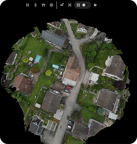
Centimeter-Accurate Drone Mapping
No more dangerous ladders or inaccurate tape measures. Extract true-to-scale measurements with our advanced drone mapping software. You deliver pinpoint accuracy that eliminates “it doesn’t fit” surprises and protects your net profit margins.
Seamless Team Collaboration
Break down the silos between your sales and engineering teams. With centralized member management and shareable live links, you gain a unified workflow that removes communication gaps and accelerates project approval times.
Workflow Integration
Render-a is the only drone based 3d solar modeling software that fits perfectly into your existing tech stack. Export high-fidelity data to PVSOL, PVsyst, and AutoCAD. You gain a flexible ecosystem that eliminates manual rework and data silos.
Demo
- Includes pre-rendered 3D models and ready-to-use files
- No credits included
- No additional users allowed
- Online support available
- Self-measurement available on demo project
- No discount on extra credit purchases
Basic
- 20 3D renders or 20 file requests
- 200 credits/month (1 €/credit)
- Add up to 2 additional users
- Online support within 7 business days
- Interactive 3D model for self-measurement
- No discount on extra credit purchases
- Generate production reports by consuming credits
F.A.Q
Render-a is a platform that generates automatic 3D models and solar project-specific analyses from drone images. It enables all stakeholders, from sales teams to engineering departments, to work from a single source.
Render-a is optimized for solar energy, but its 3D modeling, measurement, and site analysis capabilities can also be applied in agriculture, construction, roof inspection, and real estate.
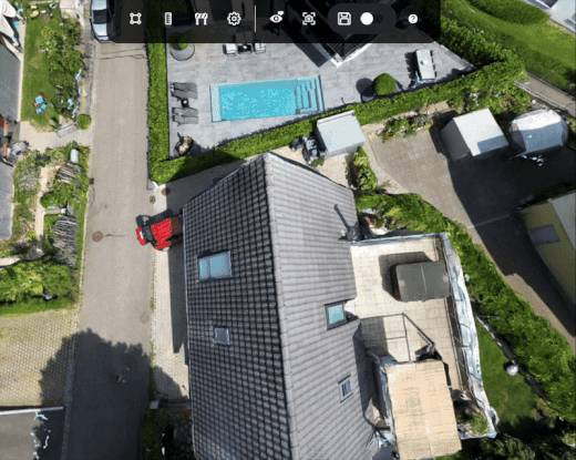
GPS and LiDAR supported drones provide the most accurate results because they allow 1:1 measurements. However, you can also generate models using photos taken with a phone with the loss of scaling.
Yes. You can use any drone you prefer. We also provide a recommended flight protocol document.
Absolutely. All data is encrypted and stored securely, accessible only from your account. For more information, please review our Privacy Policy page.
It depends on the project size and number of photos. An average rooftop project takes about 30 minutes, while a large ground-mounted project may take a few hours.
There is no strict technical limit. For very large files, we recommend uploading in parts.
Your account is credited based on the package you choose. One render costs 10 credits. If you download the 3D model to use in another platform, an additional 10 credits are deducted. You can purchase extra credits anytime through the app.
Yes. Reports are generated in PDF format, customized with your company details, and ready to share directly with your customers.
Yes. The monthly solar production forecast data is optimized for Excel integrations. Other export formats are also available for more detailed feasibility studies.
• 3D models compatible with PVSol, PVSyst, CAD and SketchUp
• Panel layout, energy yield forecast, and carbon emission saving report
• Proposal documents
Yes. Report are created to match your corporate identity.
Yes. Downloads are available in formats compatible with SketchUp, AutoCAD, PVsyst, and PVSol.
Yes. The free package includes a demo project and gives you access to all Premium features.
Of course. We provide documentation, sample projects, and email support. You can always reach us at support@render-a.com.